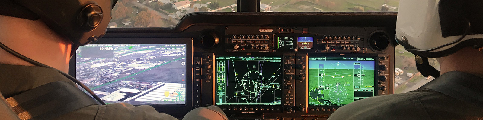
SHOTOVER ARS
ARS is the world’s leading real-time augmented reality mapping system for airborne law enforcement, search and rescue, and aerial firefighting missions. Installed in over 600 platforms across six continents, ARS provides unsurpassed situational awareness through augmented reality overlays coupled with 3D satellite and synthetic imagery.
Explore Applications
Maintain Optimal Situational Awareness
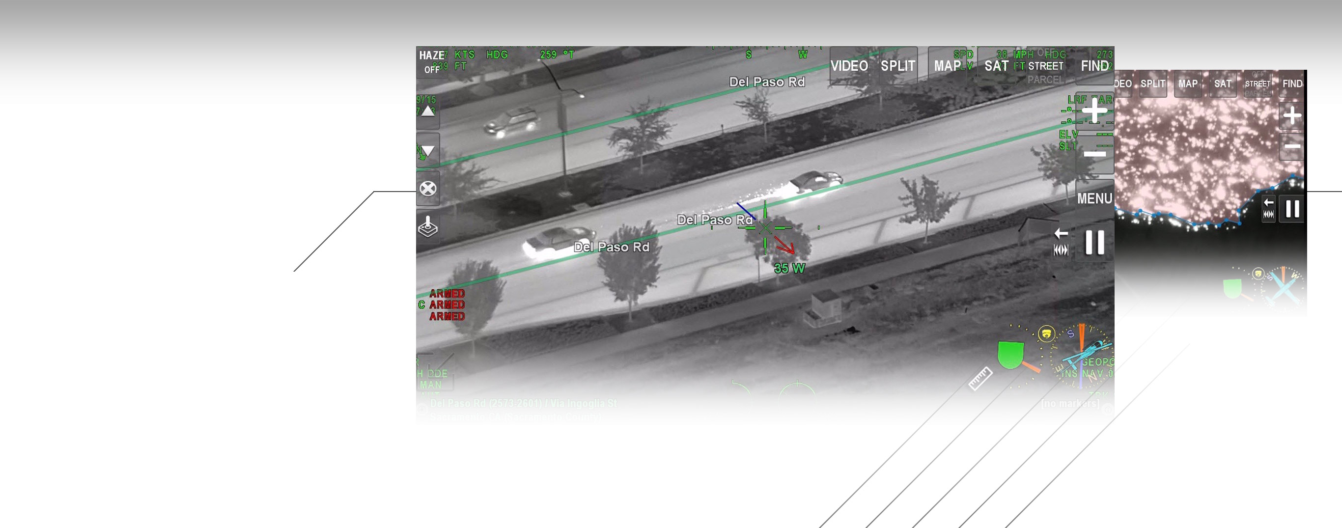
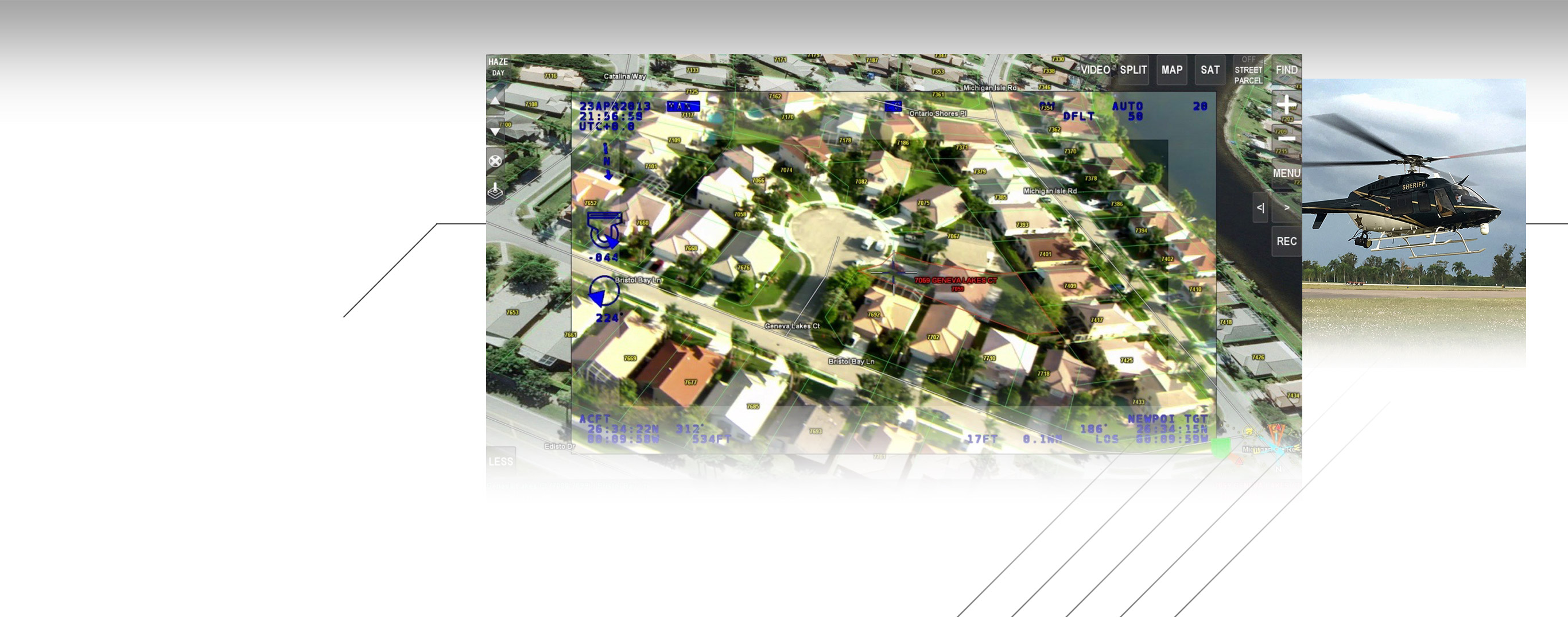
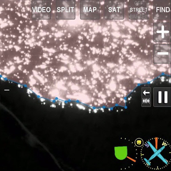
View streets, addresses, infrastructure, vehicle locations and other critical information directly on top of sensor video in real time. ARS combines all relevant mission information onto a single display, allowing TFOs the freedom to stay focused on the target and mission, rather than dividing their attention between multiple sources for video, mapping, and target information. The system’s intuitive design enables a wide range of map data display options and allows for new interface and control options per customer feedback.
- Eliminate the need for stand-alone video recorders with ARS’s built-in recording capability.
- Use our extensive imagery and GIS databases or import your own data (or let us import it for you for at no cost)
- See something and want a closer look? Pause and replay while you are still recording.
- Lifetime software updates included
- Backed by industry-leading service and support
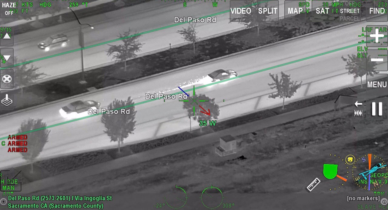
Never Miss A Moment: In a pursuit, ARS shows streets, intersections, direction of travel, speed and much more on a single display so you can have ultimate situational awareness.
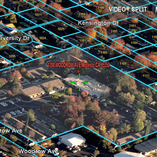
Don’t guess the address. Know it.
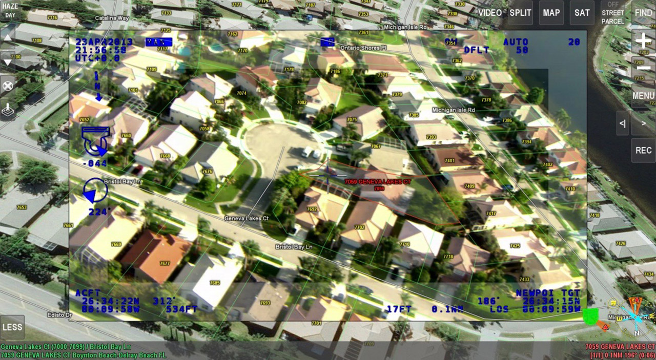
ARS features comprehensive, rooftop-accurate parcel data that gives you the confidence to know exactly where the suspect is. Use our extensive GIS data library, import your own, or let us import it for you. When the suspect is on the run, you’ll have total confidence in the pursuit.
Built-In Features for Accurate and Efficient Searches
Search and rescue operators can now view coordinates, streets, addresses and other critical types of information directly on top of sensor video in real-time. Our intuitive augmented reality overlays combine all relevant mission information onto a single display, allowing the operator to stay focused on the target and mission, rather than dividing their attention between multiple sources for video, mapping, and target information.
- Directly enter and navigate to coordinates regardless of coordinate system format.
- Built-in augmented reality trails, roads, and waterways to aid with SAR operations.
- Eliminate the need for stand-alone video recorders with ARS’s built-in recording capability.
- Reduce operator workload by creating on-the-fly search patterns and shapes and letting ARS automatically steer the camera.
- See something and want a closer look? Pause and replay while you are still recording.
- Includes lifetime software updates
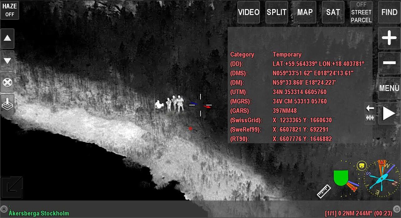
Pinpoint accuracy: When a missing person is located, the operator simply touches the screen to show coordinates in a variety of coordinate systems. These markers can be saved and reloaded if the aircraft needs to return to the scene multiple times.
Built-in features for accurate and efficient searches
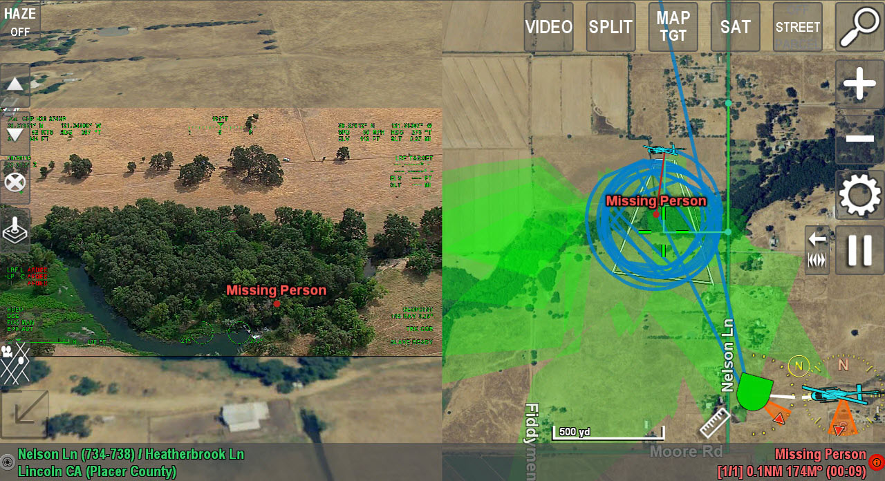
Highly accurate on-screen markers identify last known coordinates or locations of interest. Built-in breadcrumb data show the operator precisely where the search has focused — and when the aircraft needs to return for fuel or a crew change, the next operator can load the data and seamlessly resume the search without duplication of efforts.
- Custom maps, imagery, POIs, and vector data: trails, park maps, landing zones, topographic maps and more
- Built-in search patterns — Slave the camera to automatically follow search pattern lines and other dynamic line layers
- Multiple coordinate systems and real-time coordinate conversion
- Save, export and import everywhere the camera has searched or where the aircraft has flown

Accurate, Real-Time Fire Mapping
Perform Fire Mapping Directly on Top of Sensor Video in Real-Time.
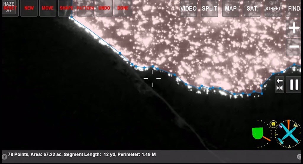
Operators can place geographic markers, create, modify, and combine polygons, as well as calculate the acreage of a polygon and measure distances. Markers, lines, and polygons created on-board the aircraft can be exported using common GIS formats.
The ability to create an accurate map of a wildfire or any other incident is literally at your fingertips. With ARS and a touch-screen display, the operator simply needs to touch the screen to create a real-time perimeter polygon. These polygons can then be downloaded to an incident commander or operations center using common GIS formats.
Built-in features for Quick and Accurate Perimeter Mapping
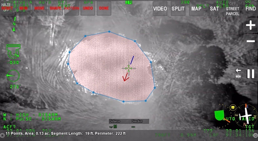
Fire mapping in ARS uses any one of several options – touchscreen, keyboard, camera, or even the aircraft, to trace the perimeter of the fire
- Custom maps, imagery, POIs, and vector data: trails, park maps, landing zones, topographic maps and much more
- Built-in GIS export lets save polygons directly to inexpensive removable USB media or email directly from the aircraft (if equipped)
- Mark the location of hotspots by simply touching the screen. Save and export to USB or view coordinates live, on-screen
- Multiple coordinate systems and real-time coordinate conversion lets you handle any type of location data

Augmented Reality Mapping for Military and Unmanned Aerial Systems
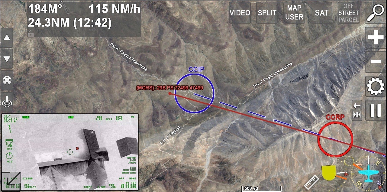
ARS is a TRL 9 flight proven mission management system that can be easily customized to interface with a broad range of equipment and signals. The system displays an array of critical information for the latest in situational awareness and decision making.
ARS includes high resolution imagery, DTED data, 3D map imagery, inclusion of NIMA and NGA data and can display a wide range of geo-located points of interest. Overlay information such as ADS-B traffic locations, weather, RADAR targets, and BFT icons on top of real time EO/IR video, giving users selectable and accurate layers of data to aid in split second decision making. All information can be presented and controlled from a single source, saving space, weight and power (SWAP), and keeping the operator focused on the target.
- Digital Moving Map / Mission Computer with built-in Cursor on Target (COT) and MTI integration
- Display EO/IR camera’s line of sight and field of view information on-screen
- Terrain avoidance features on top of live video or overlaid over a map (topographic, aerial imagery, etc.)
- Integration with radio/mesh networks, ADS-B, RADAR, and AIS data type information
- DO-160 certified
- Includes lifetime software updates and an industry-leading 100% satisfaction guarantee
UAS and Optionally Piloted Aircraft

Utilizing a bidirectional datalink, ARS can be installed in UAS platforms and controlled from the ground. The system can be used to steer the camera to specific locations.
The video and information can be recorded and down-linked back to the ground for up to the minute analysis and review. The entire mission can be controlled and reviewed from an operational command center on-ground.
Compact, Solid State Design
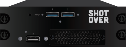
ARS operates on the ARS-750 (ATOM 2) an optimized combination of compact, light-weight design, and the latest graphics processor with maximum computing power for the lowest latency AR available. Designed for durability, the ARS-750 offers a wide range of interface potential, HD recording capability and support for 4K output.
- Dzus rail mountable
- Lightweight, weighing just 2.75 lbs.
- 7.25″ (L) x 5.75″ (W) x 1.875″ (H) (184.2 mm x 146.1 mm x 47.6 mm)
- ARS-750 gives you maximum capability with minimal impact to payload and panel space
- HD recording capability and support for 4K output
- Compatible with nearly every gimbal on the market today
- Built-in USB, serial, and Ethernet connectivity
We’re passionate about making you look great
At SHOTOVER Systems, we build our technology to give you the tools to do your job more efficiently.
Here’s some of the ways we do that:
- Be the location expert even in unfamiliar areas with our extensive mapping database.
- When seconds matter, our highly accurate search gets the aircraft, personnel and camera on target faster than ever before.
- Know which street the target is on, what intersections are coming up, direction of travel, speed and more without taking your eyes off the target.
- View and call-out rooftop addresses, business names, points of interest, parks, trails, and much more with certainty.
- Mark precise locations based on name, address, latitude and longitude, or mark and save any location you see on screen with ease.
- Record the action in HD video, save and email screenshots, control downlink systems, and search lights all from the same screen.
Service & Support: We’ve got your back
We know your mission demands your full attention. So we’re here to make things a bit easier. From software updates to equipment support contracts – whatever you need 24/7.
- Free technical support and software updates – Call or email anytime with direct access to our software and hardware engineers.
- Training – Performed at your site with no charge for our travel expenses and time.
- Customization – Tell us about your new ideas and integration need
- Map updates – There is no charge for our maps, and we’ll even install your provided map updates.
- Hardware warranty – Three-year hardware warranty included. Extendable coverage plans available.
- No hassle warranty replacement – If we cannot resolve your issue, we will send you a replacement system overnight.
If you’re not 100% satisfied, return your ARS unit within the first year and we’ll give you your money back.